

Article Summary: Best Hikes in Joshua Tree, Joshua Tree Day Hikes, Joshua Tree Trails
It may not seem like it at first glance, but there is so much diversity in Joshua Tree National Park.
The best hikes in Joshua Tree National Park vary from mountaintop trails to desert oasis destinations. There’s also a lot of cultural history to explore, including a few abandoned mines.
If you’re up for the challenge, there are more strenuous likes along ridgelines as well. Last but not least, there are enormous rocks everywhere.
There is something for every type of hiker in this magical park. Here are 20 of the best hikes in Joshua Tree organized by their attractions.
This post may contain affiliate links. If you make a purchase, I may earn a small commission at no additional cost to you. For more information, view my privacy policy.
Table of Contents
Maps of Joshua Tree National Park
Click the images below to view and/or download the full Joshua Tree hiking maps. There’s a map of the entire park as well as a detailed map of the Hidden Valley/Jumbo Rocks area. Many of the best hikes in Joshua Tree are located there.


Map of the Best Hikes in Joshua Tree National Park
Keep in Mind Before You Hike in Joshua Tree

Best Time to Visit Joshua Tree
For the mildest temperatures, plan to visit between March and April or October and November.
Spring also brings amazing wildflowers.
Summers are extremely hot and could be a dangerous time to be outside in the sun, but provide some of the best evenings for stargazing.
In the winter season, you’ll find fewer crowds and colder temperatures.
You will be hiking in the desert no matter which time of year you visit. Prepare for warm temperatures during the day and cool temperatures at night.
Bring Your Own Water
There is no water available in the park, so be sure to bring your own. Drink plenty of water (at least one gallon per person per day), use sunscreen, and wear a hat.
Do not attempt any difficult hikes listed below if you’re experiencing extreme heat during your visit.

This is a list of what I believe to be the best trails in Joshua Tree. However, there are many others! Click here for the list on the official website.

Best Hikes in Joshua Tree for Reaching the Summit
Some of my favorite Joshua Tree hikes include reaching the top of ridgelines and mountain peaks to see the incredible landscape from above. If it’s too hot, don’t push yourself. Safety first!
Hi-View
Despite some steep sections, this is a relatively easy trail. There are benches along the way to allow for breaks you may wish to take. You’ll pass through a huge Joshua Tree forest as you make your way to the top of a ridge with panoramic views.
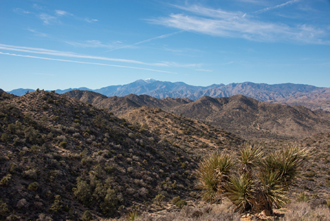
Difficulty: Easy
Distance: 1.3 mi / 2.1 km round-trip
Elevation Gain: 400 ft / 122 m
Estimated Time: 1.5 hours
Type of Trail: Loop
Map: All Trails map
Trailhead Location: Northwest of Black Rock Campground
Best For: Families, trail running, hiking, wildflowers, birds, camping
Mastodon Peak
This fantastic loop brings you through a lovely desert habitat in addition to its summit. To reach the top, there’s a small rock scramble. You do not have to complete the rock scramble to finish the loop. On the way down, you’ll also pass an old gold mine.
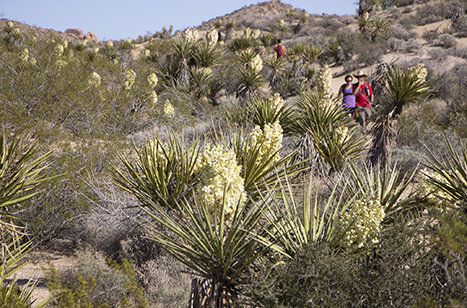
Difficulty: Moderate
Distance: 3 mi / 4.8 km round-trip
Elevation Gain: 375 ft / 115 m
Estimated Time: 1.5-2.5 hours
Type of Trail: Loop
Map: All Trails map
Trailhead Location: Cottonwood Spring parking area
Best For: Families, wildflowers, birds, and hikers of all skill levels
Ryan Mountain Trail
One of the most popular hikes in Joshua Tree, this short walk will lead to a very rewarding view. It’s one of the best trails to see the most Joshua trees as well. It will bring you to the top of Ryan Mountain for an amazing view. There are also beautiful wildflowers in peak seasons.

Difficulty: Strenuous
Distance: 3 mi / 4.8 km round-trip
Elevation Gain: 1,050 ft / 320 m
Estimated Time: 1.5-2 hours
Type of Trail: Out and back
Map: All Trails map
Trailhead Location: Parking area between Sheep Pass and Ryan Campground
Best For: Families, wildflowers
Note: There is no shade on this trail. Do not attempt in the heat.
Warren Peak
This strenuous hike to the top of Warren Peak will leave you breathless. Not only from the climb, but also the sweeping views of Joshua Tree National Park.

Difficulty: Strenuous
Distance: 6.3 mi / 10.1 km round-trip
Elevation Gain: 1,110 ft / 338 m
Estimated Time: 5-6 hours
Type of Trail: Out and back
Map: All Trails map
Trailhead Location: Black Rock
Best For: Hiking, trail running, vistas
Panorama Loop
This strenuous loop near the Warren Peak Trail has many uses. While it’s common with hikers, another option is horseback riding. Trail runners frequent the trail as well. Similar to the hikes above, expect a rewarding view of the park once you reach the top. You’ll find lots of Joshua trees in addition to pinyon pines and junipers.
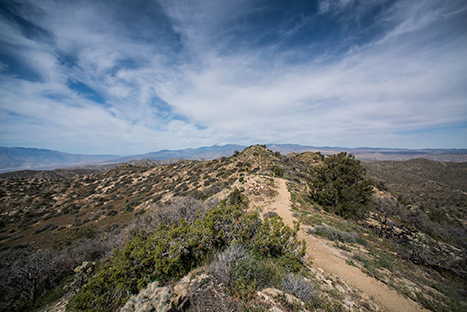
Difficulty: Strenuous
Distance: 6.6 mi / 10.6 km round-trip
Elevation Gain: 1,100 ft / 336 m
Estimated Time: 3.5-4.5 hours
Type of Trail: Loop
Map: All Trails map
Trailhead Location: Black Rock Campground
Best For: Families, trail running, horseback riding, birds, wildflowers
Best Hikes in Joshua Tree for Finding an Oasis
One of the best things to look for in the desert is a welcoming oasis. There are two popular trails in Joshua Tree that lead to one.
Fortynine Palms Oasis
You’ll hike up and over a ridge on this trail, so you can expect 300 feet in elevation gain in both directions. When you descend, you’ll find yourself in a fan palm oasis.
Note: There is no shade on this trail. Do not hike this trail if it’s too hot outside.
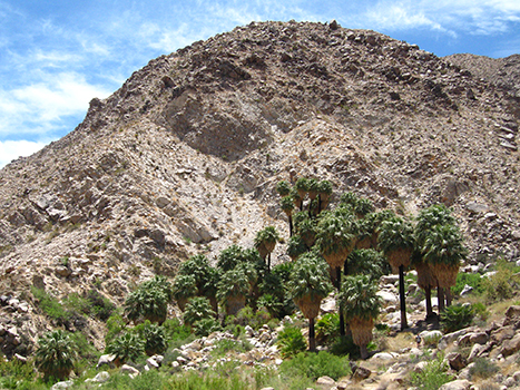
Difficulty: Moderate
Distance: 3 mi / 4.8 km round-trip
Elevation Gain: 300 ft / 91 m
Estimated Time: 2-3 hours
Type of Trail: Out and back
Map: All Trails map
Trailhead Location: Fortynine Palms parking area (on Highway 62)
Best For: Families, hiking, trail running
Lost Palms Oasis
This hike will lead you through a sandy wash before you descend down into a canyon. Here, you’ll find the fan palm oasis. The hike back out of the canyon can be strenuous.

Difficulty: Strenuous
Distance: 7.5 mi / 12 km round-trip
Elevation Gain: 500 ft / 152 m
Estimated Time: 5-6 hours
Type of Trail: Out and back
Map: All Trails map
Trailhead Location: Cottonwood Spring parking area
Best For: Hiking, rock climbing, wildflowers, birds, trail running
Best Hikes in Joshua Tree for Cultural History
Joshua Tree National Park has a fascinating history well beyond its famous plant life. There was successful gold mining here long ago, and many of the mills and mine sites still remain.
Wall Street Mill
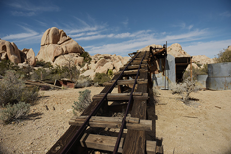
Honestly, this trail has it all. An old mill, Joshua trees, rock formations, and a lovely desert landscape. It’s relatively short with little elevation gain as well.
Difficulty: Easy
Distance: 2.4 mi / 3.8 km round-trip
Elevation Gain: 88 ft / 29 m
Estimated Time: 1.5 hours
Type of Trail: Out and back
Map: All Trails map
Trailhead Location: Near the Barker Dam parking area
Best For: Families, hiking, trail running, wildflowers, birds
Desert Queen Mine
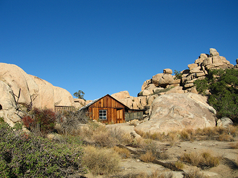
The trail leads to an old mine site along with the Eagle Cliff Boulder House. Keys Ranch can also be reached on this trail, but you must be on a guided tour with a park ranger.
Difficulty: Easy
Distance: 3.4 mi / 5.4 km round-trip
Elevation Gain: 580 ft / 177 m
Estimated Time: 2 hours
Type of Trail: Out and back
Map: All Trails map
Trailhead Location: Desert Queen Mine Road
Best For: Families, hiking, trail running, birds, wildflowers
Pine City
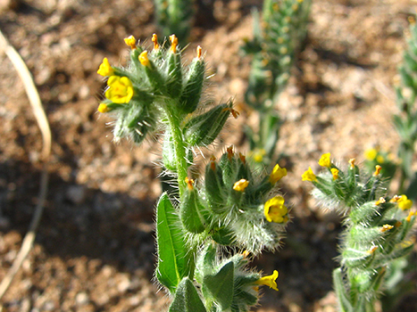
This trail does lead to a mining site, but that’s not the highlight. You’ll walk through an extravagant forest on your way there, surrounded by junipers and pinyon pine trees.
Difficulty: Moderate
Distance: 4 mi / 6.4 km round-trip
Elevation Gain: 170 ft / 52 m
Estimated Time: 2-3 hours
Type of Trail: Out and back
Map: All Trails map
Trailhead Location: Pine City trailhead at the end of Desert Mine Road
Best For: Backpacking, camping, hiking, trail running
Note: There is no shade on this trail. Do not hike when it is hot.
Lost Horse Mine
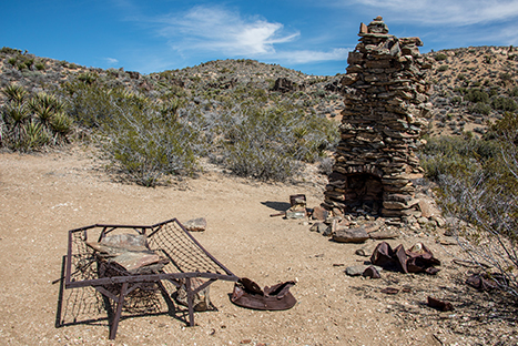
This hike can be an out and back (which is described below) or a loop (which adds about 2.5 miles to the length) known as Lost Horse Loop. Either way, you’ll find one of the most successful gold mines within the park. The mine itself is fenced in for your protection; please, don’t enter the site.
Note: There is no shade on this trail. Do not hike on hot days.
Difficulty: Strenuous
Distance: 4 mi / 6.4 km round-trip
Elevation Gain: 550 ft / 168 m
Estimated Time: 2-3 hours
Type of Trail: Out and back
Map: All Trails map
Trailhead Location: Lost Horse Mine trailhead off of Keys View Road
Best For: Hiking, trail running
Best Hikes Unique to Joshua Tree
Hoping to see a landscape unlike anything else? Head for these trails to find something only available here, making them some of the best trails in Joshua Tree.
Cholla Cactus Garden
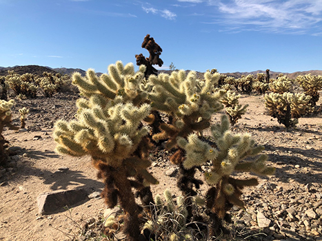
A short loop with thousands of densely concentrated cholla cacti. Remember, cactus plants are very prickly! Use caution, stay on the trail, and wear closed-toe shoes.
Difficulty: Easy
Distance: 0.25 mi / 0.4 km round-trip
Elevation Gain: 10 ft / 3 m
Estimated Time: 15-30 minutes
Type of Trail: Loop
Map: All Trails map
Trailhead Location: North of Cottonwood Visitor Center
Best For: Families, hiking, trail running, birds, wildflowers
Barker Dam Nature Trail
There’s a lake near thanks to a dam constructed decades ago. You can see the huge water tank built by cattle ranchers as well. Additionally, there may be wildlife along the trail. Look out for bighorn sheep.

Difficulty: Easy
Distance: 1.1 mi / 1.8 km round-trip
Elevation Gain: 50 ft / 15 m
Estimated Time: 1 hour
Type of Trail: Loop
Map: All Trails map
Trailhead Location: Barker Dam parking area
Best For: Families, hiking, trail running, birds, wildflowers, lake
Hidden Valley Nature Trail
Hike this short, relatively flat trail for a look at some marvelous rock formations. They appear to be from another planet. You may also encounter striking wildflowers along the way.

Difficulty: Easy
Distance: 1 mi / 1.6 km round-trip
Elevation Gain: 100 ft / 30 m
Estimated Time: 1 hour
Type of Trail: Loop
Map: All Trails map
Trailhead Location: Hidden Valley picnic area
Best For: Families, hiking, rock climbing, trail running
Best Hikes in Joshua Tree Among the Rocks
Other than the Joshua trees (of course), the park is also famous for its rocks. Climbers from around the world travel to the park to climb in this environment. Even if you’re not a rock climber, you can enjoy these formations too via hiking or even a quick scramble.
Cap Rock
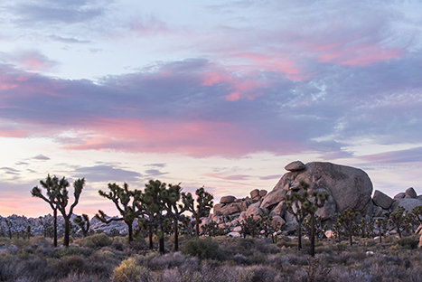
Cap Rock is a great option for those seeking a more accessible trail, as it is fully paved. On the trail, you’ll have the opportunity to see a variety of flora along with a large rock that appears to be wearing a smaller rock as a cap.
Difficulty: Easy
Distance: 0.7 mi / 1.1 km round-trip
Elevation Gain: 39 ft / 12 m
Estimated Time: 30 minutes
Type of Trail: Loop
Map: All Trails map
Trailhead Location: Keys View Road near the intersection to the main park boulevard
Best For: Families, wheelchairs, strollers, hiking, trail running, walking
Arch Rock
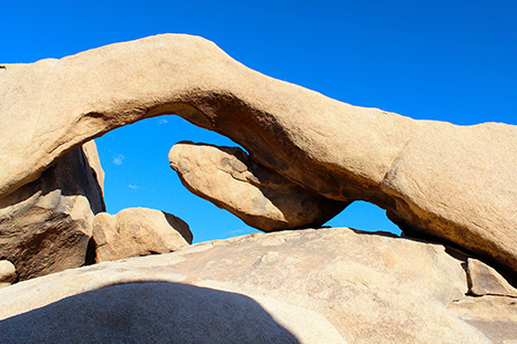
Great for wildflowers along with an arch-shaped rock formation.
Difficulty: Easy
Distance: 1.2 mi / 2 km round-trip
Elevation Gain: 88 ft / 27 m
Estimated Time: 1 hour
Type of Trail: Out and back
Map: All Trails map
Trailhead Location: Arch Rock Nature Trail parking lot
Best For: Families, wheelchairs, strollers
Skull Rock
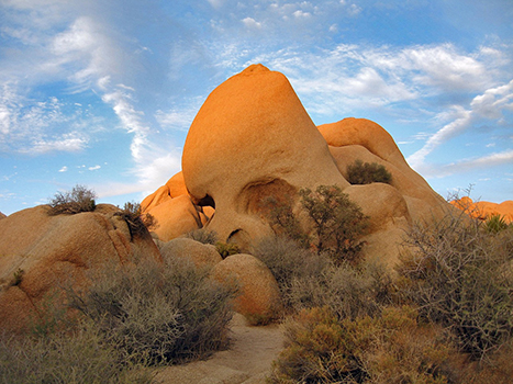
Another great rock formation, this time shaped like a skull. You can also see Skull Rock from the road.
Difficulty: Easy
Distance: 1.7 mi / 11.2 km round-trip
Elevation Gain: 160 ft / 48.7 m
Estimated Time: 1.5 hours
Type of Trail: Loop
Map: All Trails map
Trailhead Location: Jumbo Rocks Campground
Best For: Families, hiking, camping
Note: There is no shade on this trail. Use caution on hot days.
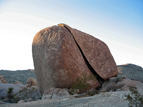
Split Rock
This rock is mysteriously split in two but barely separated. You can walk a bit farther (a short distance) to see Face Rock as well.
Difficulty: Easy
Distance: 1.9 mi / 3 km round-trip
Elevation Gain: 252 ft / 77 m
Estimated Time: 1.5-2 hours
Type of Trail: Loop
Map: All Trails map
Trailhead Location: Split Rock Road
Best For: Families, hiking, trail running
Note: There is no shade on this trail. Use caution on hot days.
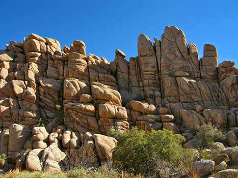
Willow Hole
This is a mostly flat trail that takes you through a divine forest of rocks and Joshua trees.
Difficulty: Strenuous
Distance: 7.2 mi / 11.5 km round-trip
Elevation Gain: 246 ft / 75 m
Estimated Time: 4 hours
Type of Trail: Out and back
Map: All Trails map
Trailhead Location: Boy Scout Trailhead
Best For: Hiking, trail running
Boy Scout Trail
This is one of the longest trails in the park meant for day hikes. It is strongly recommended that you shuttle or carpool rather than hike the full trail twice in one day to return to your starting point. The trail explores the area known as the Wonderland of Rocks.
Note: There is no shade on this trail. Avoid hiking here on hot days.

Difficulty: Strenuous
Distance: 8 mi / 12.9 km one-way
Elevation Gain: 1,190 ft / 363 m
Estimated Time: 6 hours
Type of Trail: One-way
Map: All Trails map
Trailhead Location: Indian Cove or Boy Scout Trailhead
Best For: Backpacking, camping, hiking
Best Hikes to See Joshua Trees
If you’re hoping to see as many of these rare Joshua trees are possible, many of the trails listed above will suit you. Try Barker Dam, Wall Street Mill, Hi-View, or Warren Peak to start.

What to Pack for Hiking in Joshua Tree
For more recommendations, read about my favorite outdoor gear and the best daypacks for women.

Every hiker should always carry the ten essentials with them. These include:
- Navigation systems: map, compass, and/or GPS
- Sun protection: sunscreen and/or ballcap
- Insulating layers: synthetic or down jacket, rain jacket, hat, gloves, and leggings
- Illumination (flashlight or headlamp)
- First-aid kit
- Something to light a fire: lighter, waterproof matches, and/or fire starter
- Repair kits and tools: pocket knife, duct tape, screwdriver, and/or scissors
- Emergency shelter: tent, bivy, tarp, and/or space blanket
- Nutrition: food for both meals and snacks
- Hydration: water bottle, water treatment (LifeStraw or SteriPen), and water
Joshua Tree National Park Hiking Guides
- Trails Illustrated map: waterproof; provides a great overview of the park
- Hiking Joshua Tree National Park: a great book with details on even more Joshua Tree hikes
- Joshua Tree and Palm Springs: a guidebook for the park and the surrounding area
Pin Best Hikes in Joshua Tree National Park
What are your favorite hikes in Joshua Tree National Park? Share them with us in the comments!


Joshua Tree National Park Pennant

Fodor’s Guide to the 63 National Parks

Women’s National Parks Checklist T-Shirt

Women’s National Parks Checklist T-Shirt

Map of National Parks T-Shirt

Joshua Tree National Park Sticker

Joshua Tree National Park Pin

Joshua Tree National Park Patch

Joshua Tree National Park Earrings

Joshua Tree National Park Earrings

Joshua Tree National Park Earrings

63 National Parks Water Bottle

Joshua Tree National Park Sticker

California National Parks Face Mask

Joshua Tree National Park

Joshua Tree National Park Candle


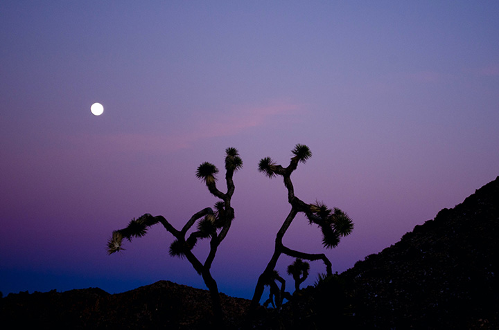


Joshua Tree is probably my favorite national park – I haven’t visited them all, but I’ve been to Joshua Tree in January and April and the landscape is just breathtaking! After reading your post, I realize that I’ve only scratched the surface. We did a lot of hikes/walks around Hidden Valley and Desert Queen Ranch, but we have to do more in the southern part of the park!
Wow. What a detailed post on all the great things to do in JT. It was the first place we took our kids rock climbing and they loved it. Our favorite was the 49 Palms Oasis hike. It’s a wonderful family friendly park.
I’m glad you had such a great time! Joshua Tree is an absolutely amazing park.
So many amazing hikes! How do you even choose from this list of “best hikes”? If there are so many awesome hikes, I can’t imagine how many hikes you could possibly do in Joshua Tree!
I’d definitely want to do Barker Dam Nature Trail, and not only because you said it was easy. That photo is so gorgeous!
It’s not easy! Honestly, there isn’t a bad hike in the park. 🙂