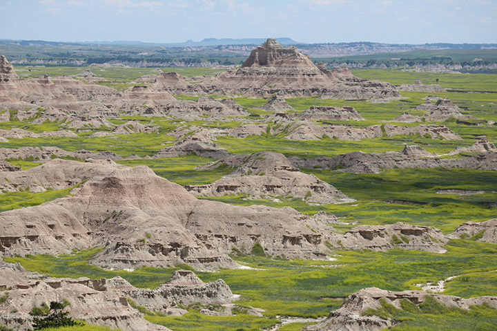
Article Summary: Hiking in Big Bend National Park, Big Bend National Park Hikes
In the southwest corner of Texas, you’ll find a majestic place on the bend of the Rio Grande: Big Bend National Park. This remote wilderness is ideal for outdoor recreation of all kinds, including backpacking, paddling, camping, and hiking.
Big Bend National Park hikes encompass everything from desert hot springs to impressive geologic formations to mountain vistas. The park is truly a gem with unique Big Bend National Park hikes waiting to be explored. Below are some of my absolute favorites.
This post may contain affiliate links. If you make a purchase, I may earn a small commission at no additional cost to you. For more information, view my privacy policy.
Table of Contents
Big Bend National Park Overview: What You Need to Know Before Hiking in Big Bend National Park

Best Time to Visit Big Bend National Park
It’s best to visit Big Bend National Park in the spring or fall. Winter is also a great season to visit if you aren’t married to the idea of climbing snow-free mountain peaks.
Wondering how long to stay in Big Bend National Park? Check out our 3-Day Big Bend Itinerary for ideas on how to spend a long weekend in the park.
How to Get to Big Bend National Park
The only way to get to Big Bend National Park is by car. The closest major airport is located in El Paso, about 4.5 hours from the park.
There is an Admission Fee for Big Bend National Park
The fee to enter Big Bend National Park is $30/car, $25/motorcycle, or $15/pedestrian. If you live in the area or visit the park often, you can also purchase an annual pass to Big Bend for $55.
In order to save money, I would recommend purchasing a national parks pass. These cost $80 and are valid for a full calendar year (from the date of purchase) at all public lands in the United States. After you visit 3 national parks, it’ll have paid for itself. It also makes a great gift for national park enthusiasts! Learn more about park entry fees.

Big Bend National Park Isn’t Very Pet-Friendly
Like in most national parks, pets in Big Bend are not allowed on trails, off roads, or in the rivers. They are also not permitted to pass through the Port of Entry to Boquillas, Mexico.
Remember, these restrictions are for the safety of you and your pet. Wildlife and other natural occurrences in nature could be very dangerous for you and for them.
Map of Big Bend National Park
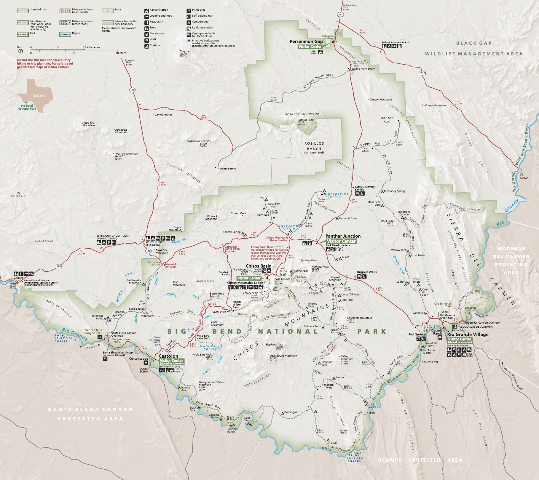
Please click on the map to enlarge it and download it.
Big Bend National Park is Comprised of Three Districts
In getting to know the park, you’ll discover how much it varies depending on where you go.
Chisos Basin
This is the mountainous area of the park. Located in the heart of Big Bend National Park, it’s also the most popular area for hiking and visiting.
Castolon and Ross Maxwell Scenic Drive
Along the Ross Maxwell Scenic Drive, one of the best things to do in Big Bend National Park, you’ll find a variety of Big Bend hikes. Many of them are on our list. This area varies from high desert to low canyons.
Rio Grande Village
The Rio Grande Village is in the southern part of the park along the Rio Grande. This area is full of more scenic hikes and drives and is not as popular as the other two districts.
Essential Tips for Hiking in Big Bend National Park
Weather
The weather in Big Bend can be unpredictable. When hiking in the park, make sure you check the conditions. Things can change rapidly.
The two most important things to watch for are flash flooding and lightning. If heavy rain or thunderstorms are expected, it’s best to cancel your hiking plans.
Remember that the park is located in a desert. You should drink more water than you normally would and avoid hiking in the heat of the day.
Wildlife
Big Bend is home to venomous snakes, scorpions, black bears, mountain lions, and more. Give wild animals plenty of space and never feed them. If you take off your shoes, check for pests before putting them back on.
What to Pack for Big Bend National Park Hikes
Big Bend National Park is located in the heart of the Chihuahuan Desert. Long sleeves, long pants, boots, and sun hats are recommended year-round for sun protection. For more suggestions, read my posts on my favorite outdoor gear and the best daypacks for women.
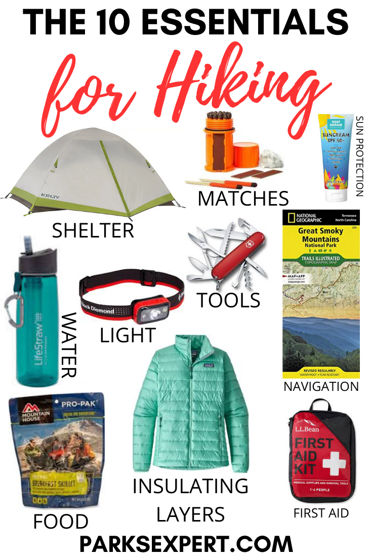
The 10 Hiking Essentials
Every hiker should always carry the ten essentials with them. These include:
- Navigation systems: map, compass, and/or GPS
- Sun protection: sunscreen and/or ballcap
- Insulating layers: synthetic or down jacket, rain jacket, hat, gloves, and leggings
- Illumination (flashlight or headlamp)
- First-aid kit
- Something to light a fire: lighter, waterproof matches, and/or fire starter
- Repair kits and tools: pocket knife, duct tape, screwdriver, and/or scissors
- Emergency shelter: tent, bivy, tarp, and/or space blanket
- Nutrition: food for both meals and snacks
- Hydration: water bottle, water treatment (LifeStraw or SteriPen), and water
Big Bend National Park Hikes

Below are some of my favorite Big Bend National Park hikes, ordered from easiest to most difficult. No matter how much time you have or how much hiking you choose to embark on in the park, choosing a few of these trails for your Big Bend itinerary will not disappoint.
Things to Know Before You Go Hiking in Big Bend National Park
- Bring a lot of water with you! Many of these Big Bend National Park hikes are on trails with limited shade in a relentless desert. It is recommended that each person carry at least 2-3 liters of water on each trail.
- Big Bend National Park is bear country. While Mexican Black Bears are typically not aggressive, make sure to practice bear safety while hiking in Big Bend.
- Two popular trails in the park lead to Hot Springs. When I visited the park during the COVID-19 pandemic, both were closed. Therefore, you won’t find them on this list. I have heard both are worth a stop, but I won’t recommend anything I haven’t done.
Window View Trail

This short, paved trail is located near the Chisos Basin Visitor Center. Less than a mile, the loop provides a beautiful summary of the Chisos Basin with views of the famous Window, stunning landscapes, and some beautiful Juniper trees and other plants. The easy trail is also wheelchair-accessible. If you can only squeeze in one of these Big Bend National Park hikes, this trail is a spectacular overview that won’t take too much time.
Difficulty: Easy
Distance: 0.3 mi / 0.5 km round-trip
Elevation Gain: 13 ft / 4 m
Type of Trail: Loop
Estimated Time: 15 minutes
Lower Burro Mesa Pour-off Trail

Pour-offs are something I hadn’t heard of until hiking in Big Bend National Park. Finding these spectacular, unique geologic formations was a treat. In flash floods, impressive waterfalls cascade down the pour-offs, perfectly eroding the rock to form a column-like cavern. In Big Bend, this hike includes hiking through a canyon, which provides some rare and much-appreciated shade before you reach the climactic end.
Difficulty: Easy
Distance: 1 mi / 1.6 km round-trip
Elevation Gain: 144 ft / 44 m
Type of Trail: Out and back
Estimated Time: 45 minutes
Rio Grande Village Nature Trail

This trail is unlike any other hike in Big Bend National Park. When you picture Big Bend, you don’t necessarily think of a marsh habitat filled with fish, turtles, and frogs, but that’s what you’ll find on the trail’s boardwalk. Then, stroll through the familiar desert before ascending to an overlook with spectacular views of the Rio Grande Valley and Boquillas, Mexico.
Difficulty: Easy
Distance: 1 mi / 1.6 km round-trip
Elevation Gain: 80 ft / 24 m
Type of Trail: Lollipop
Estimated Time: 1 hour
Santa Elena Canyon Trail

One of the most popular hikes in Big Bend National Park is the Santa Elena Canyon Trail. Known for its scenic beauty, the trail features a wonderful variety of vistas and hiking. You’ll cross Terlingua Creek, climb a few switchbacks, then gradually descend to the shores of the famous Rio Grande.
Along the way, enjoy multiple ecosystems and terrain types along with a bit of shade. Do not hike this trail during flash floods or storms, which could render Terlingua Creek impassable.
Difficulty: Easy
Distance: 1.5 mi / 2.4 km round-trip
Elevation Gain: 610 ft / 186 m
Type of Trail: Out and back
Estimated Time: 1 hour
Grapevine Hills Trail to Balanced Rock

Commonly referred to as the Balanced Rock Trail due to its ending highlight, the Grapevine Hills Trail leads you through a landscape unlike any other in Big Bend National Park. If you’ve been to the Black Hills in South Dakota, it may remind you of the Cathedral Spires of Custer State Park.
After walking through the geologic wonderland, the last 1/4-mile of the maintained trail takes you up a rock scramble to fantastic views of the Chihuahuan Desert through the window created by the famous Balanced Rock.
IMPORTANT NOTE: To reach the trailhead, you’ll need to drive down a gravel road. 4-wheel drive vehicles with high clearance are recommended.
Difficulty: Moderate (easy if you elect not to do the rock scramble at the end)
Distance: 2.2 mi / 3.5 km round-trip
Elevation Gain: 80 ft / 24 m
Type of Trail: Out and back
Estimated Time: 1.5 hours
Mule Ear Spring Trail

The maintained trail leads to an old spring and a historic corral with views of the Mule Ears rock formation. If you continue, the trail is no longer maintained and therefore considered primitive. It will take you through the foothills of the Chisos Mountains as you walk toward the Mule Ears and cattails in the overgrown spring.
If the hike sounds too challenging, you can see the Mule Ears formation from the overlook in the trailhead parking area.
PARKS EXPERT TIP: This trail has no shade. It is best to hike here in the early afternoon or early evening to avoid the heat of the day. Bring lots of water and sun protection.
Difficulty: Moderate
Distance: 3.8 mi / 6.1 km round-trip
Elevation Gain: 410 ft / 125 m
Type of Trail: Out and back
Estimated Time: 2 hours
Boquillas Canyon Trail

From the parking area, you’ll gradually climb a small hill before you descend once again to the shores of the Rio Grande. The trail provides a variety of terrain, including rocks, desert, cattails, and even small trees.
One highlight at the end, especially for younger visitors searching for interesting Big Bend National Park hikes, is a small, smooth hill made of sand that you can slide down. If you’d prefer to hike only one canyon, this one is less crowded than Santa Elena.
Along the trail, you’ll find souvenirs for sale left by residents of Boquillas, Mexico (which is just across the river). The National Park Service asks visitors not to purchase items as it encourages illegal border crossings.
Difficulty: Easy
Distance: 1.2 mi / 2 km round-trip
Elevation Gain: 230 ft / 70 m
Type of Trail: Out and back
Estimated Time: 1 hour
Lost Mine Trail

Lost Mine is one of the best Big Bend National Park hikes for scenic views. Rated as moderate, there is some gradually steep climbing involved after the first mile. If you’re not up for that, hike the first mile to the first scenic viewpoint and then turn back to avoid most of the elevation gain.
If you’re up to the challenge, complete the hike by climbing through the forests before reaching the ridge for mind-blowing scenic views.
If you only have time for one hike in the park, I would choose this one. On hot days, this is also a great option. The Chisos Basin area is already cooler due to its high elevation and this trail has more shade than most other hikes in Big Bend National Park.
PARKING NOTE: The parking area for this trailhead is extremely small. Arrive early (before 7:30 a.m.) to find a spot. If they’re all taken, consider hiking an alternate trail from the Chisos Basin Visitor Center.

Difficulty: Moderate
Distance: 4.2 mi / 6.8 km round-trip
Elevation Gain: 1,099 ft / 335 m
Type of Trail: Out and back
Estimated Time: 3 hours
Window Trail

One of the most popular Big Bend National Park hikes, the Window Trail offers multiple scenic vistas of incredible rock formations and desert canyons. If you can’t find parking at Lost Mine, this trail is a great back-up option.
The Window Trail begins near the Chisos Basin Campground, perfect if you’re staying there and hope to get an early start. Beginning at the campground will also shorten your hike by about one mile. You’ll also be treated to a lovely waterfall.
Do not hike this trail during flash floods or storms. Be prepared for little or no shade.
Difficulty: Moderate
Distance: 5.2 mi / 8.4 km round-trip (one mile less if you begin at the campground)
Elevation Gain: 948 ft / 289 m
Type of Trail: Out and back
Estimated Time: 4 hours
Emory Peak Trail

One of the most popular Big Bend National Park hikes takes you to the top of the park, and nearly the top of Texas (for the true high point, visit Guadalupe Mountains National Park).
Rising above the park at 7,832 feet, the summit delivers outstanding views. Need a break? There are plenty of backcountry campsites along the route. If you have more time and are up for a challenge, consider the South Rim Trail, detailed below.
Difficulty: Strenuous
Distance: 10 mi / 16.1 km round-trip
Elevation Gain: 2,513 ft / 766 m
Type of Trail: Out and back
Estimated Time: 5 hours
Emory Peak via South Rim Trail and Boot Springs Trail

Considered one of the premier Big Bend National Park hikes, this loop is guaranteed to take your breath away (both from the views and the difficulty). If you wish to see Santa Elena and Boquillas Canyon from an eagle’s point of view, look no further than the South Rim Trail.
The hike is undoubtedly strenuous, but incredibly rewarding. Make sure to hike the loop counter-clockwise and be diligent about wildlife – bears have been reported in this area.
Difficulty: Strenuous
Distance: 14.9 mi / 24 km round-trip
Elevation Gain: 3,166 ft / 965 m
Type of Trail: Loop
Estimated Time: 8 hours
Where to Stay When Hiking in Big Bend National Park

There are many campgrounds and one lodge you could stay in while visiting Big Bend.
The most popular option is the Chisos Mountain Lodge in the Chisos Basin. This hotel features private rooms and cabins in the heart of the beautiful mountains.
Camping in Big Bend National Park
For those who don’t mind sleeping under the wide-open skies, I’d recommend adding a few nights of camping to your Big Bend National Park itinerary.
There are campgrounds in the Chisos Basin and the Rio Grande Village as well as the Cottonwood Campground near Santa Elena Canyon.
You could move camp each night after spending a day in those areas of the park or stay at Chisos Basin for the entirety of your trip as it is the most centrally located. Just remember it is at the top of winding roads that will add significant travel time.
If you’re traveling with an RV, you could also consider staying at the Rio Grande Village RV Park.
Is everything in the park full? Here’s a handy list of campgrounds outside park boundaries.
Does staying in a campground or lodge sound too crowded for you? Backcountry camping is always an option as well.
Pin Our Favorite Big Bend National Park Hikes