

Article Summary: Death Valley Hikes, Hiking Death Valley, Death Valley Hiking Map
Death Valley is the largest U.S. national park outside of Alaska, which means there are plenty of things to see and do. One of the best ways to see this incredible park is on foot. Here is a list of the best hikes in Death Valley ranked by difficulty.
This list of trails in Death Valley includes scenic vistas, cultural history, summit attempts, and easy strolls. No matter which Death Valley hiking trails you choose, you won’t be disappointed by this spectacular park.
This post may contain affiliate links. If you make a purchase, I may earn a small commission at no additional cost to you. For more information, view my privacy policy.
Table of Contents
Map of Death Valley National Park

You can click on the map above to view and download the map in its entirety. If you’re interested in a detailed map of the Furnace Creek area, click here to download one.
Map of the Best Hikes in Death Valley National Park
Tips for Hiking in Death Valley National Park
When to Go: It’s important to use caution when hiking in Death Valley. For the mildest temperatures, plan to visit between March and April or October and November. Spring also brings amazing wildflowers. Summers are extremely hot and could be a dangerous time to be outside in the sun, but provide some of the best evenings for stargazing. In the winter season, you’ll find large crowds and cooler temperatures.
You will be hiking in the desert no matter which time of year you visit. Prepare for warm temperatures during the day and cool temperatures at night. Drink plenty of water (at least one gallon per person per day), use sunscreen, and wear a hat. Do not attempt any difficult hikes listed below if you’re experiencing extreme heat during your visit.
This is a list of what I believe to be the best hikes in Death Valley.

Best Hikes in Death Valley National Park
Here are the best hiking trails in Death Valley, organized from the easiest to the most challenging. To explore more of the park, check out my 2-day Death Valley itinerary.
1. Harmony Borax Works
If you want to learn more about the cultural history of Death Valley National Park, this easy trail is a good place to start. Waysides along the way will share information about the history of borax processing at this site along with the famous 20-mule teams in the park.

Difficulty: Easy
Distance: 0.4 mi / 0.6 km round-trip
Elevation Gain: 50 ft / 15 m
Estimated Time: 30 minutes
Type of Trail: Loop
Map: All Trails map
Trailhead Location: One mile west of Furnace Creek on CA-190
Best For: Wheelchairs, strollers, families
2. Salt Creek Interpretive Trail
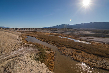
One of the best places to see pupfish, the Salt Creek trail is a boardwalk that leads to a small creek. There is only water from approximately November to May. The best time to hike this trail is from February to April when the Salt Creek Pupfish are spawning. This is also a great trail for bird watching. Of all the easy trails in the park, this is one of the best hikes in Death Valley.
Difficulty: Easy
Distance: 0.5 mi / 0.8 km round-trip
Elevation Gain: Negligible
Estimated Time: 30 minutes
Type of Trail: Loop
Map: All Trails map
Trailhead Location: Salt Creek Road
Best For: Wheelchairs, families, strollers, birding, pupfish
3. Natural Bridge
Years and years ago, a rush of water created this natural arch in a rock formation in Death Valley National Park. The walk is relatively easy and short, but can be rocky. The trail does continue beyond the bridge, but not for long before abruptly ending at a dry waterfall. If you’ve seen arches in Arches National Park or other parks in the southwest, you can skip this trail opt for one of the other best hikes in Death Valley.

Difficulty: Easy
Distance: 1 mi / 1.6 km round-trip
Elevation Gain: 86 ft / 26 m
Estimated Time: 45 minutes
Type of Trail: Out and back
Map: All Trails map
Trailhead Location: Natural Bridge Road
Best For: Families, hiking, birding
4. Badwater Salt Flat
The Badwater Basin is the lowest point in North America at 282-feet below sea level. You can walk out to the beautiful white salt flats on this flat trail. There is also a boardwalk where you can see the salt basin and take a picture with the sign. If you face toward the parking area from the boardwalk, you can see a sign where sea level is located nestled in the rocky cliffs. If you only have time for one short hike in Death Valley, choose this trail.

Difficulty: Easy
Distance: 1 mi / 1.6 km round-trip
Elevation Gain: Negligible
Estimated Time: 30 minutes to 1 hour
Type of Trail: Out and back
Map: All Trails map
Trailhead Location: Badwater Road
Best For: Families, walking
5. Mesquite Flat Sand Dunes
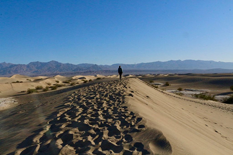
One of the most easily accessible dune fields in the park, the Mesquite Flat Sand Dunes are a must-see. There is no true trail here, and you can really walk as far or as little as you’d like, one of the reasons I’ve chosen the trail as one of the best hikes in Death Valley. The tallest dune is approximately one mile (one-way) from the parking area. Walking along the dunes at night provides excellent star gazing!
Difficulty: Moderate
Distance: 2 mi / 3.2 km round-trip
Elevation Gain: 185 ft / 65 m
Estimated Time: 1.5 hours
Type of Trail: Out and back
Map: All Trails map
Trailhead Location: Parking area west of Stovepipe Wells Village
Best For: Families, walking
6. Darwin Falls
The most difficult part of the hike to Darwin Falls is finding the unmarked dirt road. You could also be unlucky like we were and find it is closed when you arrive. You’ll find the road 1.2 miles west of Panamint Springs.
The trail is also unmarked. It’s fairly flat but can be rocky. You’ll find thick vegetation and some stream crossings once you enter the canyon. This oasis is very fragile and rare in the desert ecosystem, so please protect it by staying on the trail and not swimming in the pool.

Difficulty: Moderate
Distance: 2 mi / 3.2 km round-trip
Elevation Gain: 450 ft / 137 m
Estimated Time: 1.5-2 hours
Type of Trail: Out and back
Map: All Trails map
Trailhead Location: Darwin Falls Road
Best For: Families, trail runners, rock scrambles
Note: No swimming!
7. Golden Canyon-Gower Gulch-Badlands Loop
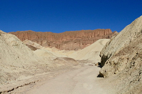
From Golden Canyon or Zabriskie Point, there is a network of trails to walk. You can make a few different loops by combining these or arrange to carpool if you hope to hike from one to the other. More details on the various routes are available here. If you’re trying to decide between the best hikes in Death Valley with different canyons to explore, our favorite was Mosaic (#9 on the list).
Difficulty: Moderate to Strenuous
Distance: 3 to 8 mi routes / 4.8 to 12.9 km routes
Elevation Gain: 535 to 834 ft / 163 to 254 m
Estimated Time: 1.5-4.5 hours
Type of Trail: Out and back or loop depending on the route you choose
Map: All Trails map
Trailhead Location: Golden Canyon Trailhead or Zabriskie Point
Best For: Hiking, rock scrambles, geology
8. Desolation Canyon
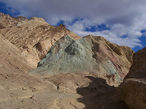
Through this canyon, you’ll find a great adventure. There’s no true trail, only an unmarked route with several rock scrambles. You can find more details on this Death Valley hike here.
Difficulty: Moderate
Distance: 3.6 mi / 5.8 km round-trip
Elevation Gain: 600 ft / 183 m
Estimated Time: 2.5 hours
Type of Trail: Out and back
Map: All Trails map
Trailhead Location: Golden Canyon parking lot
Best For: Experienced hikers
9. Mosaic Canyon
This was one of our favorite things we did in Death Valley National Park. The trail itself is quite long with almost zero shade, but you’ll find that the best parts of the trail occur along the first 1/2-mile. This is the narrowest part of the slot canyon with the brightest colors and smoothest stone. You can find more information here. Of all the best hikes in Death Valley, Mosaic Canyon is my favorite.

Difficulty: Moderate
Distance: 4 mi / 6.4 km round-trip
Elevation Gain: 1,200 ft / 366 m
Estimated Time: 2.5-3 hours
Type of Trail: Out and back
Map: All Trails map
Trailhead Location: Mosaic Canyon Road
Best For: Families, rock scrambles, experienced hikers
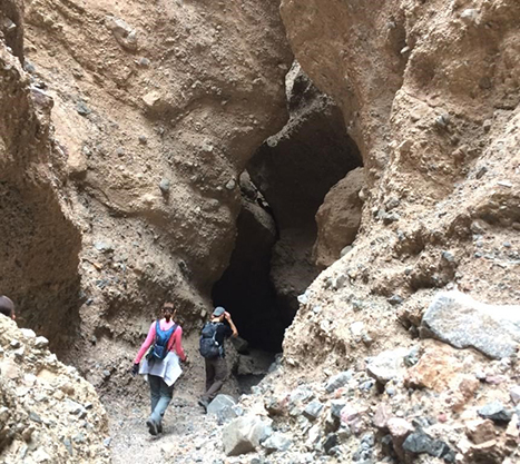
10. Sidewinder Canyon
For even more twists and turns inside a slot canyon, Sidewinder provides some of the best claustrophobic hiking in Death Valley. You can find more detailed route information here. This hike is considered strenuous, so use caution in the passageways.
Difficulty: Strenuous
Distance: 5 mi / 8.4 km round-trip
Elevation Gain: 1,580 ft / 482 m
Estimated Time: 6 hours
Type of Trail: Out and back
Map: All Trails map
Trailhead Location: Unmarked gravel access road between mile markers 31 and 32 on Badwater Road
Best For: Experienced hikers, rock scrambles
Note: There is little-to-no shade on this trail.
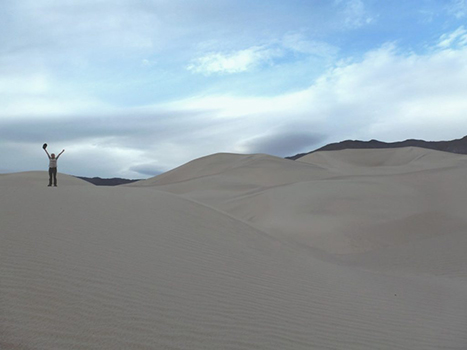
11. Panamint Dunes
If you loved the Mesquite Flat Sand Dunes and you’re itching for more, check out the Panamint Dunes. Of all the best hikes in Death Valley, this is one of the most remote. These are much harder to get to and therefore much less crowded. Use caution as the route is unmarked, uneven, and rocky. You’ll reach the dunes after walking about 3 miles. From there, it’s up to you to decide how far you wish to go.
Difficulty: Strenuous
Distance: 8 mi / 12.8 km round-trip
Elevation Gain: 1,028 ft / 313 m
Estimated Time: 4-5 hours
Type of Trail: Out and back
Map: All Trails map
Trailhead Location: Unmarked cross country route off of Lake Hill Road; high clearance vehicle required.
Best For: Experienced hikers, off-trail hiking
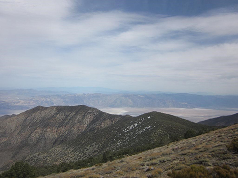
12. Wildrose Peak
Our final two best hikes in Death Valley lead to mountain summits. The first, Wildrose Peak, is located in a remote part of the park near the Wildrose Charcoal Kilns and Wildrose Campground. It’s a great trail if you’re seeking solitude and scenic vistas, but is very strenuous and remote. More information is available on the official site.
Difficulty: Strenuous
Distance: 8.4 mi / 13.5 km round-trip
Elevation Gain: 2,200 ft / 671 m
Estimated Time: 6 hours
Type of Trail: Out and back
Map: All Trails map
Trailhead Location: Charcoal Kilns parking area
Best For: Scenic views, experienced hikers, solitude, historic site
13. Telescope Peak
The tallest mountain in Death Valley National Park, the trail to the top of Telescope Peak is also the longest. It begins near the Charcoal Kilns, one of the best things to see in Death Valley, and is an extremely remote trail. It leads to epic views of almost the entire park, including Badwater Basin thousands of feet below. This is one of the best hikes in Death Valley for the uninterrupted views of the rest of the park. Detailed descriptions of the trail are available here.

Difficulty: Strenuous
Distance: 14 mi / 22.5 km round-trip
Elevation Gain: 3,000 ft / 914 m
Estimated Time: 7 hours
Type of Trail: Out and back
Map: All Trails map
Trailhead Location: Charcoal Kilns parking area
Best For: Rock scrambles, experienced hikers, scenic vistas
Where to Stay in Death Valley National Park
There are a total of five lodges within the park.
- The Ranch: Of the hotels in Furnace Creek, this is the significantly cheaper option. It’s an older hotel, but the location can’t be beaten.
- The Inn: This 4-star hotel is much nicer than the Ranch, and therefore twice as expensive. Be prepared to shell out the cash for any luxury. Located in Furnace Creek.
- Panamint Springs Resort: This place doesn’t have great reviews, but if you’re hoping to save money it may be your best option. Located in Panamint Springs.
- The Inn Casitas: The third property in Furnace Creek is also the newest.
- Stovepipe Wells: There’s a hotel, restaurant, and gift shop located in this small complex just a few minutes north of Furnace Creek in Stovepipe Wells.

Camping in Death Valley National Park
In total, there are nine campgrounds in Death Valley National Park. By far, this is the cheapest lodging in Death Valley. Furthermore, it provides great access to the best hikes in Death Valley. You can read more about the campgrounds here.
- Furnace Creek: This is the only campground that accepts reservations (during the peak winter season). It is open year-round.
- Sunset and Texas Springs: These campgrounds are also located in Furnace Creek.
- Stovepipe Wells: This is another year-round campground in the park. It’s about 30 minutes away from Furnace Creek if you’d like a little quiet but don’t want to be too far away from the center of the park.
- Mesquite Springs: About 1 hour and 15 minutes from Furnace Creek for a more remote experience. Open year-round.
- Emigrant: This is a tents-only campground about 40 minutes from Furnace Creek.
- Wildrose, Thorndike, and Mahogony Flat: Typically closed in winter due to snow, but open in the summer season. Located at higher elevations for some cooler air.
What to Wear Hiking in Death Valley
For more suggestions, read my posts on my favorite outdoor gear and the best daypacks for women.
The 10 Hiking Essentials
Every hiker should always carry the ten essentials with them. These include:

- Navigation systems: map, compass, and/or GPS
- Sun protection: sunscreen and/or ballcap
- Insulating layers: synthetic or down jacket, rain jacket, hat, gloves, and leggings
- Illumination (flashlight or headlamp)
- First-aid kit
- Something to light a fire: lighter, waterproof matches, and/or fire starter
- Repair kits and tools: pocket knife, duct tape, screwdriver, and/or scissors
- Emergency shelter: tent, bivy, tarp, and/or space blanket
- Nutrition: food for both meals and snacks
- Hydration: water bottle, water treatment (LifeStraw or SteriPen), and water
Death Valley National Park Guides
I’m a big believer in guidebooks. My favorites are the ones written by Lonely Planet as they’re the most detailed while also managing to be the most concise. I have the National Parks guidebook below as well as the USA guidebook and many other worldwide destinations. I download the ebooks and then they’re with me everywhere I go on my travels, significantly lightening my load.
I also carry (and collect) the Trails Illustrated maps of national parks. They’re sturdy, waterproof, and provide a great overview. If I’m backpacking or hiking, I’ll purchase a topographic map that is centered on the area I’m in so that I have more detail. But for road tripping or to have the big picture in your hands, Trails Illustrated is the way to go. They create maps for U.S. National Parks as well as international destinations.
Some more favorites include the Falcon Guides for hiking. These detail everything you need to know from how to get to places, trail distances, and elevation changes. Moon Guides are my runner-up to Lonely Planet but still have great information. Last but not least, I love learning about the places I visit by reading about them. I’ll do this through books or vehement internet research, but there’s just something about holding that book in your hands, am I right?
Purchase some of my recommendations below. You can also find more Death Valley-related books and souvenirs on the official website.


More from Death Valley National Park

Death Valley National Park Phone Case

Death Valley National Park Pennant

Fodor’s Guide to the 63 National Parks

Women’s National Parks Checklist T-Shirt

Women’s National Parks Checklist T-Shirt

Map of National Parks T-Shirt

Death Valley National Park Sticker

Death Valley National Park Pin

Death Valley National Park Patch

63 National Parks Water Bottle

Death Valley National Park Sticker

Death Valley Sticker

California National Parks Face Mask

Death Valley National Park Map
Pin The Best Hikes in Death Valley National Park




I have wanted to visit Death Valley National Park for years! It’s just such a cool landscape! Thanks for sharing your favorite hikes. I’m putting this on the top of my list!
I hope you make it there soon!
Riley, Another impressive guide. Death Valley is a late bloomer on my bucket list. I’ve been to many areas all around it but never there. This post has more reasons to consider it. I love your passion for maps and guides. I’m a map junkie–real ones, not so much GPS ones.
Glad you’re finding these guides helpful! I hope you’re bookmarking them for future travels.
These look fantastic!
To start with I was surprised by how short the easy trails are- but I guess that makes sense as it gets so hot. Having some super-easy options is good for allowing everyone to see the epic scenery!
The strenuous hikes must be reeeally tough when you’re carrying a couple of liters of water for each hour on the trail! The views from the peaks do look tempting though!
p.s. LOVE this new site and that you’ve added the alltrails maps.
Thanks, Josy!