

Article Summary: Best Hikes in Rocky Mountain National Park, Rocky Mountain National Park Trails
With over 355 miles of hiking trails, it’s easy to get lost in the beauty of Rocky Mountain National Park.
It can be difficult to choose a trail, not to mention which sights to see. There are so many lakes, waterfalls, and alpine wonders to whet your pallet.
Below, you’ll find a list of the best hikes in Rocky Mountain National Park for every type of hiker, organized by difficulty (easy to strenuous).
This post may contain affiliate links. If you make a purchase, I may earn a small commission at no additional cost to you. For more information, view my privacy policy.
Table of Contents
Top 5 Things to Know About Hiking in Rocky Mountain National Park
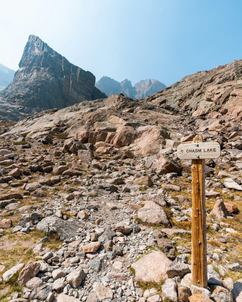
Rocky Mountain National Park is All About Elevation
The elevation in the Rocky Mountains is likely much higher than you are used to. It’s best to stay in the area for at least one night before hiking in Rocky Mountain National Park to help your body adapt.
This is especially critical if you plan to gain elevation while you hike. If you start to feel light-headed or like it’s difficult to breathe, turn around immediately and descend.
Trail conditions vary significantly depending on the time of year. Check current conditions on the official website. This place will also alert you of any recent closures.
When visiting our national parks and public lands, please practice Leave No Trace principles. Plan ahead, choose durable surfaces for camping or hiking, dispose of all waste properly, leave everything you find, minimize campfire impacts, respect wildlife, and be considerate of other park visitors.
There is a Reservation System to Access Rocky Mountain National Park
Rocky Mountain is one of the parks that now requires reservations on a timed-entry system. If you plan to visit between late May and mid-October, you need to visit Recreation.gov to secure your reservation. This includes access to all areas of the park, from Estes Park to Grand Lake. Each timed entry permit is $2 and includes everyone in your vehicle.
If you’re interested in hiking around the Bear Lake area, this is the timed entry permit for you. It’s the only one that’ll allow you to drive the Bear Lake corridor. If you want to hike in another area of the park, stick with the basic timed entry permit.
Timed entry permits are released on a rolling basis throughout the reservation period. On the first date of each month, you can make reservations for the following month. For example, beginning June 1, you can make reservations for any date between June 1 and July 31. The ticketing portal opens at 8 a.m. MST. If you didn’t plan ahead, the park also releases about 40% of the permits at 7 p.m. MST the night before each entry date.
Reservations do not guarantee parking spots, especially at popular locations such as Bear Lake Road. You will also still need to pay your park entrance fee.
You do not need an entrance fee to visit the park from mid-October to late May.
Use the Park Shuttle to Avoid Crowded Parking Lots
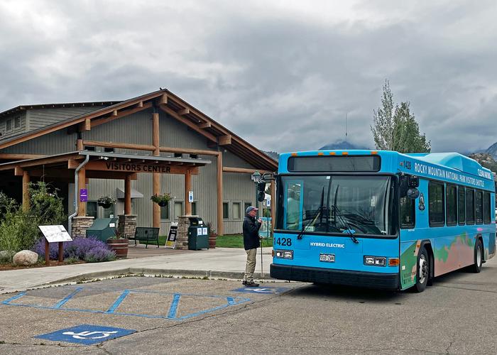
Rocky Mountain is one of the most popular national parks in the country. Parking and traveling on the park’s roads can be a nightmare with crowds and traffic. To address overcrowding, they have introduced a shuttle system.
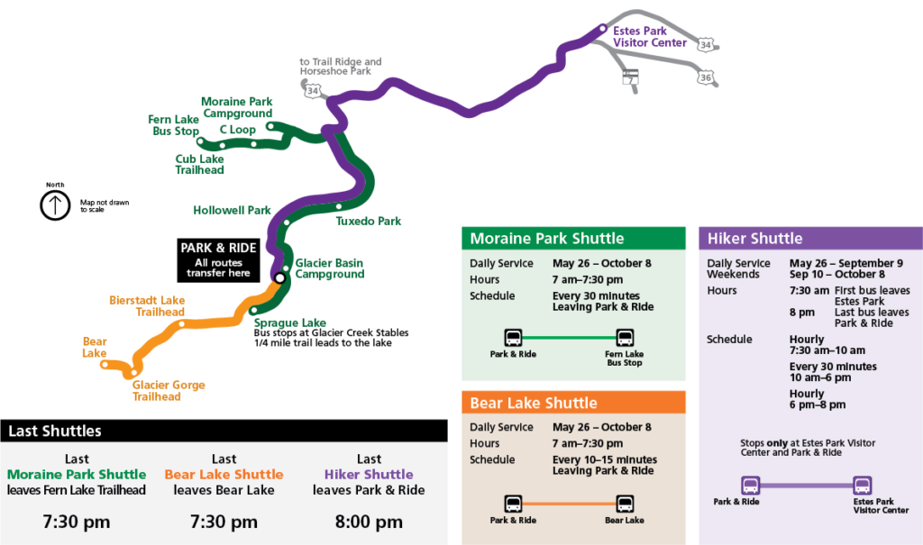
Rocky Mountain National Park Shuttle Summary:
The Bear Lake Shuttle will stop at Bierstadt Lake, Bear Lake, and Glacier Gorge trailheads. The Moraine Park Shuttle will stop at Sprague Lake, Glacier Basin Campground, Hollowell Park, Tuxedo Park, Moraine Park Campground (C Loop), Fern Lake Bus Stop, and Cub Lake Trailhead. The Hiker Shuttle will bring you to the Park and Ride where you can transfer to either the Bear Lake or Moraine Park shuttle to begin your hike (it doesn’t stop at any trailheads).
There are a few places you can park to hop on the shuttle. One is the Estes Park Visitor Center, located outside the park. This is where the Hiker Shuttle picks up, a perfect option for hiking in Rocky Mountain National Park. The shuttle will drop you off at the Park and Ride where you can transfer to the other two routes. Since you aren’t entering the park in your own vehicle, you won’t need a timed entry permit.
However, you do have to reserve your Hiker Shuttle tickets in advance on Recreation.gov for $2. Everyone in your party needs a ticket, and each person can purchase up to 4 tickets. If you have more than 4 people in your party, you’ll need more than one person to make reservations for your group. This is in addition to park entrance fees.
You can also park in the Park and Ride lot, where every route on the shuttle map below intersects. This is the best spot to park if you don’t have hiker shuttle passes. Hopping on the Moraine Park or Bear Lake routes from this location is free, but you will need a timed entry pass to enter the park during peak season.
For more about the shuttle system in the park, click here. Don’t forget to check out our post on driving Trail Ridge Road to learn more about getting around!
There is A Fee to Enter Rocky Mountain National Park
In addition to the timed entry and hiker shuttle passes above, everyone will also need to purchase their park entrance. This can be purchased at the fee station when you arrive or online in advance. To visit the park for one day, it’s $30 per vehicle, $25 per motorcycle, and $15 per pedestrian/cyclist. To visit for 7 days, it’s $35 per vehicle, $30 per motorcycle, and $20 per person/cyclist.
In order to save money, I would recommend purchasing a national parks pass. These cost $80 and are valid for a full calendar year (from the date of purchase) at all public lands in the United States. After you visit 3 national parks, it’ll have paid for itself. It also makes a great gift for national park enthusiasts! Learn more about park entry fees.

When is the Best Time to HIKE IN Rocky Mountain National Park?
Rocky Mountain National Park is busiest in the summer when temperatures are milder and there’s less snowfall. This is also the best weather for hiking in Rocky Mountain National Park. To prepare for a summer visit, make sure you secure all your reservations and passes in advance. This will guarantee a smoother trip.
If you want to avoid crowds or timed entry passes and shuttle tickets, we recommend visiting in the spring or fall. There are some things to be aware of, like snowmelt, avalanches, road closures, and rutting elk. It’s also best for cooler weather, fall foliage, and colorful tundra. Remember to stay safe and vigilant no matter when you visit the park, and check the official website for up-to-date conditions.

Rocky Mountain National Park Map
Click the image below to enlarge and download the map.

Best Easy Hikes in Rocky Mountain National Park
- Adams Falls
- Bear Lake
- Nymph Lake
- Alberta Falls
- Dream Lake
Adams Falls
Adams Falls is one of the easier waterfall hikes in Rocky Mountain National Park. The trail is 0.7 miles round-trip and heavily trafficked. It can be muddy when wet.

Difficulty: Easy
Distance: 0.3 mi / 0.5 km one-way
Elevation Gain: 79 ft / 24 m
Map: All Trails map / Kawuneeche Valley Trail Guide
Trailhead: East Inlet
Parking: There is a large parking area with restrooms located at 3045 W Portal Rd, Grand Lake, CO 80447.
Best For: Families, horseback riding
Bear Lake

The loop around Bear Lake is partly paved and partly packed down gravel, making it one of the easiest and most popular trails in Rocky Mountain National Park. It’s also accessible for those with a mobile disability who may rely on a wheelchair.
The lake is stunning with lovely reflections of the mountains and trees surrounding it. It’s especially beautiful in the fall when the colorful foliage is on display and reflected in the lake waters.
You can also hike the Bear Lake Trail in the winter. The trail can be icy, so you should be cautious. We recommend packing your snowshoes.
This is one of the best hikes in Rocky Mountain National Park if you want to get out of the car, stretch your legs, and see some gorgeous scenery without actually doing much hiking.
Difficulty: Easy
Distance: 0.5 mi / 0.8 km one-way
Elevation Gain: 20 ft / 6 m
Maps: All Trails map / Bear Lake Summer Guide / Bear Lake Winter Guide
Trailhead: Bear Lake
Parking: There is a large parking area at the end of Bear Lake Road.
Best For: Families, wheelchairs, strollers
Nymph Lake

This partially paved trail also begins from the parking lot at the Bear Lake Trailhead. It can be steep in places, but is still considered one of the easier hikes in Rocky Mountain National Park.
You can continue beyond Nymph Lake to reach Dream and Emerald Lakes as well, a popular option. This is also a good option if you’re adjusting to the altitude in the park. You will gain just enough elevation to help your body adjust.
Remember to stay on the trail to keep the area wild. Hikers love the lily pads on the surface of this small lake.
Difficulty: Easy
Distance: 0.5 mi / 0.8 km one-way
Elevation Gain: 225 ft / 69 m
Map: All Trails map / Bear Lake Summer Guide / Bear Lake Winter Guide
Trailhead: Bear Lake
Parking: There is a large parking area at the end of Bear Lake Road.
Best For: Families, cross-country skiing
Alberta Falls

Another one of the best hikes in Rocky Mountain National Park, Alberta Falls is also one of the most popular. Many consider Alberta Falls to be the most beautiful waterfall in the park.
The short walk to 25-foot Alberta Falls can be quite crowded. You’ll begin at the Glacier Gorge trailhead and follow Tyndall and Glacier Creeks to the falls. You’ll be treated to glorious evergreens and aspens as you ascend.
If you continue along the trail, you can also visit The Loch, Mills Lake, Lake Haiyaha, and Black Lake. We highly recommend continuing if you want to escape the crowds.
This is a short hike with a huge reward. While it is considered easy, it is almost entirely uphill with uneven terrain and loose rocks.
Difficulty: Easy
Distance: 0.8 mi / 1.3 km one-way
Elevation Gain: 160 ft / 49 m
Map: All Trails map
Trailhead: Glacier Gorge
Parking: The Glacier Gorge Trailhead parking area is located at 4852-4854 Bear Lake Rd, Estes Park, CO 80517.
Best For: Families, horseback riding, snowshoeing
Dream Lake

After passing Nymph Lake, continue on the trail to Dream Lake. One of the prettiest in the park, this is a great spot for a picnic on the flat rocks on the lakeshore.
The views from this trail are breathtaking. You’ll see more and more rocky peaks as you climb. Flattop Mountain is particularly stunning here. There are plenty of places to rest and take some photos along the way. Walking along the lakeshore provides incredible views as well.
At sunrise, there are nearly crystal clear reflections in Dream Lake. It’s a popular spot for photography as a result. Doing this hike early will reward you with sunrise views and fewer people. You may even see some wildlife!
While Dream Lake is beautiful, and perhaps the most beautiful along this trail that leads to a total of four lakes, if you can we recommend continuing on to Emerald Lake. This portion of the trail is a bit more difficult, so we’ve included it in our section on moderate hikes in Rocky Mountain National Park.
Difficulty: Easy
Distance: 1.1 mi / 2.7 km one-way
Elevation Gain: 425 ft / 130 m
Map: All Trails map / Bear Lake Summer Guide / Bear Lake Winter Guide
Trailhead: Bear Lake
Parking: There is a large parking area at the end of Bear Lake Road.
Best For: Families, skiing, snowshoeing
Best Moderate Hikes in Rocky Mountain National Park
- Bierstadt Lake
- Gem Lake
- Emerald Lake
- Lake Haiyaha
- Cub Lake
- Ouzel Falls
- Lake Helene
- The Loch Lake
- Fern Lake
- Odessa Lake
- Lake Ypsilon
Bierstadt Lake

Bierstadt Lake is another crowded trail in the park. The trail can be slushy/muddy in the winter or when wet.
There is some elevation gain at the beginning of the hike as you make your way up a rock face. After that, it’s an easy walk through the forest before you reach the lake.
After the climb, you’ll come to an intersection with the Bierstadt Lake Loop. If you don’t want to do the full loop (about 1 mile long), going right will bring you to the lake fastest. We do think the mountain views from the other side of the lake are better if you have the time and energy.
Difficulty: Moderate
Distance: 1.4 mi / 2.3 km one-way
Elevation Gain: 566 ft / 173 m
Map: All Trails Map
Trailhead: Bierstadt Lake
Parking: There is a small parking area for Bierstadt Lake Trailhead along Bear Lake Road.
Best For: Families, horseback riding, snowshoeing
Gem Lake

PARKS EXPERT TIP: Since this trail begins outside the park boundary, you don’t need a timed entry permit to drive or park here!
The trail to Gem Lake provides excellent views of Estes Park below. It’s especially great for watching the sunset over the town. Especially with Long Peak looming in the distance.
The trail includes many steps up to the lake. It is open year-round, but hikers should use caution in winter as the trail does get icy.
You’ll walk uphill the entire way to the lake, getting steeper as you climb, so be prepared. Especially if you haven’t adjusted to the altitude. The trail includes several stairs as you ascend, passing boulder fields as you weave in and out of the forest. Although it is a strenuous trail, it’s still a good hike for kids thanks to its big pay off.
About halfway up, you’ll get your first major break in the trees and glimpse your first amazing views of Estes Park below.
If you’ve got the time and energy, the trail continues to the Twin Owls Loop and Bridalveil Falls.
NOTE: Due to nesting peregrine falcons, this area could be closed at certain times of the year. Check the park website and social media before you go.
Difficulty: Moderate
Distance: 1.6 mi / 2.6 km one-way
Elevation Gain: 1000 ft / 305 m
Map: All Trails Map / Fall River Trail Guide
Trailhead: Lumpy Ridge
Parking: To park, follow Devils Gulch Road to Lumpy Ridge Road from Estes Park. There is a small parking area located at approximately 1435 Lumpy Ridge Rd, Estes Park, CO 80517.
Best For: Experienced hikers, solo hikers, camping
Emerald Lake

Emerald Lake is often regarded as the very best hike in Rocky Mountain National Park. On the way there, you will pass Bear Lake, Nymph Lake, and Dream Lake. With so many beautiful places to see, this is one of the most popular hikes in the park. That said, the farther up the trail you hike, the fewer people you’ll see.
The path is paved for the first 0.5 miles and provides excellent views of nearby peaks, including Flattop Mountain and Hallett Peak. The trail from Dream Lake to Emerald Lake is the hardest section of the hike with steep inclines and several stairs.
You will hike to more than 10,000 feet in elevation on this trail, so pay close attention to your body to make sure you’re capable of the climb. As you walk, enjoy the meadows, small waterfalls, wildflowers, and scenic vistas.
Do yourself a favor and take a shuttle to this crowded trailhead to avoid a headache.
Hiking this trail, you get to see four alpine lakes in a fairly short distance. No wonder it’s considered one of the best hikes in Rocky Mountain National Park!
Difficulty: Moderate
Distance: 1.8 mi / 2.9 km one-way
Elevation Gain: 605 ft / 184 m
Map: All Trails map / Bear Lake Summer Guide / Bear Lake Winter Guide
Trailhead: Bear Lake
Parking: There is a large parking area at the end of Bear Lake Road.
Best For: Families, snowshoeing, fishing
Lake Haiyaha

This hike has it all, making it one of the best trails in Rocky Mountain National Park. On the way to Lake Haiyaha, you’ll find a waterfall, beautiful forests, and snowy mountain peaks with incredible views.
One of the easier ways to hike to Lake Haiyaha is via the trail between Nypmh and Dream Lake. It’ll add about 2 miles to your hike along the Emerald Lake Trail. It’s a pretty tough 2 miles as it’s mostly uphill. Toward the end, you have to do a bit of rock scrambling to reach the water. The lake sits atop Chaos Canyon, which is excellently named as the sight is quite surreal.
You can return the way you came or descend via Glacier Gorge to see Alberta Falls. This will make your trip a bit longer (7.8 miles round-trip)
Difficulty: Moderate
Distance: 2.1 mi / 3.4 km one-way
Elevation Gain: 745 ft / 227 m
Map: All Trails map / Bear Lake Summer Guide / Bear Lake Winter Guide
Trailhead: Bear Lake
Parking: There is a large parking area at the end of Bear Lake Road.
Best For: Families, solo hikers
Cub Lake

Finally, we’re starting to get into the trails that are much less crowded. If you’re hoping to avoid crowds, Cub Lake is a decent choice. It’s also one of the best hikes in Rocky Mountain National Park for a chance of spotting elk in the valley.
You’ll still be rewarded for your hike with beautiful mountain and lake views. Similar to Nymph Lake, this one is also covered in lily pads. Due to a 2012 fire, it may not be as photogenic as other lake hikes in Rocky Mountain National Park. That said, it’s a nice trail through a cool, damp forest.
For a longer and more strenuous hike, you can also reach Cub Lake from Bear Lake.
You can turn back and descend the way you came or, for a longer trek, hike to The Pool and Fern Lake bus stop for a 5.9-mile loop.
Difficulty: Moderate
Distance: 2.3 mi / 3.7 km one-way
Elevation Gain: 540 ft / 165 m
Map: All Trails map / Bear Lake Summer Guide / Bear Lake Winter Guide
Trailhead: Cub Lake
Parking: There is a small parking area along Fern Lake Road near the Moraine Park Campground.
Best For: Solo hikers, experienced hikers, trail runners, snowshoeing
Ouzel Falls

This waterfall hike is slowly gaining popularity but remains one of the less-crowded waterfall hikes in the park.
There are many ways to get there, but the Wild Basin Trail is the most scenic route. You’ll pass Copeland Falls and the Calypso Cascades along your hike. With three waterfalls in one short trip, this is easily one of the best hikes in Rocky Mountain National Park.
The waterfalls are best during the early spring snowmelt.
Difficulty: Moderate
Distance: 2.7 mi / 4.3 km one-way
Elevation Gain: 950 ft / 290 m
Map: All Trails map / Wild Basin Area Map / Wild Basin Winter Guide
Trailhead: Wild Basin
Parking: There is a small parking area at the Wild Basin trailhead. The road to get there is unpaved.
Best For: Solo hikers, experienced hikers, trail runners
Lake Helene

You’ll find crowds once again on this hike from Bear Lake. However, the farther you walk on the Fern Lake Trail, the more isolated you will become.
On the way to Lake Helene, you’ll find various types of trees (including a really cool aspen grove), a boulder field, flowering meadows, and gorgeous views.
There’s an unmarked trail leading to the lake from a steep ridge. It’s easy to miss, so keep your eyes peeled!
The trail continues to Fern Lake and Odessa Lake, which we’ll cover later in this post, for a longer, 8.9-mile hike. We recommend hiking from the Bear Lake Trailhead to the Fern Lake Bus Stop and using the shuttle to return to your vehicle. It’s a much more scenic route with an easier descent.
Difficulty: Moderate
Distance: 2.9 mi / 4.7 km one-way
Elevation Gain: 1215 ft / 370 m
Map: All Trails map / Bear Lake Summer Guide / Bear Lake Winter Guide
Trailhead: Fern Lake
Parking: There is a large parking area at the end of Bear Lake Road.
Best For: Solo hikers, horseback riding, snowshoeing
The Loch Lake

For breathtaking views, look no further than The Loch. From here, you’ll get a view of Andrews Glacier along with some stunning alpine scenery.
You can also take the Fern Lake Trail, but Glacier Gorge is much more scenic. Plan for the hike to take about a half-day to complete. It can be extremely windy at the lake. You can also continue to Andrews Glacier or Sky Pond.
This hike will offer some of the best scenery of any trail on this list.
Difficulty: Moderate
Distance: 3 mi / 4.8 km one-way
Elevation Gain: 990 ft / 302 m
Map: All Trails map / Bear Lake Summer Guide / Bear Lake Winter Guide
Trailhead: Glacier Gorge
Parking: There is a large parking area at the end of Bear Lake Road.
Best For: Solo hikers, horseback riding, snowshoeing, trail runners
Fern Lake

On the Fern Lake Trail, traffic will start to dwindle. If you continue to Odessa Lake (next on the list), you’ll encounter even fewer people and one of the prettiest lakes in the park.
The trail follows the Big Thompson River, offering breathtaking views of the rushing river, mountain peaks, and waterfalls. You’ll also see the Arch Rocks and The Pool as you hike. The climb to Fern Falls is steep but worth it!
The northern shoreline of the lake offers the best views of the jagged peaks in the distance.
Difficulty: Moderate
Distance: 3.8 mi / 6.1 km one-way
Elevation Gain: 1375 ft / 419 m
Map: All Trails map / Bear Lake Summer Guide / Bear Lake Winter Guide
Trailhead: Fern Lake
Parking: There is a small parking area at the end of Fern Lake Road.
Best For: All hikers, horseback riding, fishing, trail runners
Odessa Lake

There are many ways to reach Odessa Lake, the most popular route being from Bear Lake.
Alternatively, you could begin on the Fern Lake trail and hike past Cub Lake and Fern Lake on your way here. From Bear Lake, it’s a short detour to Lake Helene and Two Rivers Lake.
Of all the Rocky Mountain National Park trails, this is one of my favorites. Especially if you hike early in the morning when the water is calm and the reflections are unbelievably beautiful.
Similar to the Emerald Lake Trail, you’ll pass several alpine lakes on your way to Odessa Lake: Fern Lake and Lake Helene. While this trail is more difficult, it is also less crowded. If you can handle the distance and terrain, we recommend this trail for a scenic hike that will avoid the crowds.
Difficulty: Moderate
Distance: 4.1 mi / 6.6 km one-way
Elevation Gain: 1215 ft / 370 m
Map: All Trails map / Bear Lake Summer Guide / Bear Lake Winter Guide
Trailhead: Bear Lake or Fern Lake
Parking: You can park in the small lot at the end of Fern Lake Road or the large lot at the end of Bear Lake Road, depending on where you begin.
Best For: Camping, horseback riding, all hikers
Lake Ypsilon

One of the longest moderate hikes, but also one of the best hikes in Rocky Mountain National Park, the trek to Lake Ypsilon is worth every step.
Highlights along the route include Chipmunk Lake, Ypsilon Mountain, Mount Chiquita, and an unnamed waterfall.
Expect a steady climb through the lush ponderosa pine forest to reach the lake, but nothing too difficult.
Difficulty: Moderate
Distance: 4.5 mi / 7.2 km one-way
Elevation Gain: 2180 ft / 664 m
Map: All Trails map / Fall River Hiking Guide
Trailhead: Lawn Lake
Parking: At the end of Old Fall River Road, there are a couple of small parking lots. Look for signs for the Lawn Lake trailhead.
Best For: Experienced hikers, solo hikers, horseback riding
Best Strenuous Hikes in Rocky Mountain National Park
- Mills Lake
- Twin Sisters Peak
- Chasm Lake
- Flattop Mountain
- Mount Ida
- Sky Pond
- Black Lake
- Andrews Tarn and Andrews Glacier
- Bluebird Lake
- Longs Peak via The Keyhole Route
Mills Lake

This trail might be my favorite of all the hikes in Rocky Mountain National Park. The hike to reach the lake is absolutely stunning, and the lake itself offers peace and quiet.
In addition to the sub-alpine lake, you will also find waterfalls and rapids along the way. Highlights include Alberta Falls, Glacier Creek, and Icy Brook. Views of Longs Peak will become more prevalent as you climb.
You have the option to turn back here or add another 4 miles to your hike and visit Black Lake.
Difficulty: Strenuous
Distance: 2.8 mi / 4.5 km one-way
Elevation Gain: 750 ft / 229 m
Map: All Trails map / Bear Lake Summer Guide / Bear Lake Winter Guide
Trailhead: Glacier Gorge
Parking: There is a large parking area at the end of Bear Lake Road.
Best For: All hikers
Twin Sisters Peak

You may have noticed something about the easy and moderate hikes on this list: they all include lakes.
As we get into more strenuous hikes in Rocky Mountain National Park, we’ll also find some trails that lead to mountain summits. While this isn’t our favorite hike on the list, it’s a great option to avoid the crowds.
One of the most popular summits is Twin Sisters Peak near the Lily Lake Visitor Center. This rugged trail weaves through Rocky Mountain National Park and the bordering Roosevelt National Forest.
It’s a strenuous climb with a rock scramble at the end of the trail to reach the summit. You’ll have amazing views of Estes Park, surrounding mountains, and the Continental Divide from the apex.
Keep an eye out for pika and marmots as you hike!
Difficulty: Strenuous
Distance: 3.7 mi / 6 km one-way
Elevation Gain: 2338 ft / 713 m
Map: All Trails map
Trailhead: Twin Peaks
Parking: Park at the small lot for Lily Lake on S St Vrain Ave. Access is via dirt road only.
Best For: Experienced hikers, horseback riding, snowshoeing
Chasm Lake

Chasm Lake is highly regarded as one of the top hikes in Rocky Mountain National Park.
The strenuous and rugged route to Chasm Lake is consistently uphill. You’ll want to allow yourself 4-6 hours to complete this hike safely. The hike begins at nearly 10,000 feet and it’s important to know what you’re capable of before you begin.
On this hike, you’ll pass beautiful alpine tundra, Alpine Brook, Peacock Pool, and Columbine Falls. The most outstanding parts of the trail are showcased once you’re above the treeline.
Half of the trail is exposed with no shade or protection from thunderstorms or snow, so it’s best to hike early in the morning.
To reach the lake, you’ll have to follow cairns through a rock scramble, the truly strenuous element of the trail.
If you need it, there’s an outhouse at the junction for Longs Peak Trail.
The obvious highlight is the beautiful, up-close views of Longs Peak, the only 14-er in Rocky Mountain National Park. You may even see other hikers who are on their way to the summit of the park’s tallest mountain.
Difficulty: Strenuous
Distance: 4.2 mi / 6.8 km one-way
Elevation Gain: 2360 ft / 719 m
Map: All Trails map / Longs Peak Area Map
Trailhead: Longs Peak
Parking: There’s a small lot near the Longs Peak campground you can park in.
Best For: All hikers, horseback riding, snowshoeing
Flattop Mountain

Need a break from sub-alpine lakes? This is the mountain summit trail for you. Visible from most of the easy or moderate hikes on this list, it’ll be cool to see the park from its summit.
You’ll begin at Bear Lake but leave the huge crowds behind as you begin your uphill jaunt through the forest. While still a popular trail, it’s nowhere near as crowded as the lakes below. Hallett Peak will be a prominent feature on your journey.
Most of the trail is through the pine forest. The aptly named Flattop summit doesn’t have the best views, but you can skirt down the mountainside a bit for some dramatic scenery.
Difficulty: Strenuous
Distance: 4.4 mi / 7 km one-way
Elevation Gain: 2849 ft / 868 m
Map: All Trails map / Bear Lake Summer Guide / Bear Lake Winter Guide
Trailhead: Follow the Bear Lake trail to Flattop Mountain trail.
Parking: There is a large parking area at the end of Bear Lake Road.
Best For: All hikers, solo hikers, cross-country skiing, snowshoeing
Mount Ida

The number one thing to prepare for before summiting Mount Ida is wind. Be prepared for cold weather, even in the summer; pack layers, gloves, and a hat with you. Remember to prepare for potential altitude illness, too.
This hike is mostly on the Continental Divide Trail. With its high elevation, you spend very little time below the tree line. This leads to sweeping 360-degree panoramic views of the scenic park below. You’ll feel like you’re hiking on top of the world on this steady uphill climb.
After the first 1/2-mile of the trail, you’ll be above the treeline and on subalpine tundra. While there is a maintained trail, it can be difficult to find at times. Stay vigilant to ensure you don’t get lost.
When you leave the tree line is also when you should analyze the weather and determine whether it’s safe to continue. If it’s overcast, park rangers recommend turning around to avoid such exposure in case of lightning.
You’ll share the path with pretty cool wildlife and have the potential to view bighorn sheep, elk, and marmots.
Difficulty: Strenuous
Distance: 4.8 mi / 7.7 km one-way
Elevation Gain: 2,388 ft / 728 m
Map: All Trails map
Trailhead: Ute Trail to Mount Ida Trail (Continental Divide Trail)
Parking: There’s a small parking area at Poudre Lake along Trail Ridge Road.
Best For: All hikers, solo hikers, trail runners
Sky Pond

Sky Pond is one of the most popular strenuous hikes in the park and a favorite for locals. It’s easy to see why: it has everything! You’ll see alpine lakes, waterfalls, mountainous views, and traverse a few streams.
The area is nicknamed Loch Vale (lake valley) as you’ll pass multiple lakes and waterfalls on your climb.
To reach Sky Pond, you’ll have to climb up the side of Timberline Falls. This waterfall scramble is the most challenging part of the hike. You’ll want to stay to the right of the falls and be very careful as you climb the slick surface. This can be refreshing in warmer weather, but rather unpleasant when it’s cold. You will need to do this again to descend and should use extra caution when doing so.
Once you’re at the top of the climb, continue another 0.5 miles to Sky Pond. You’ll see the Lake of Glass first, which is nice but is decidedly not Sky Pond. You may need to follow rock cairns to find the trail. The lake is surrounded by majestic rock spires.
If you can only do one hike in the park and can acclimate appropriately, this is one to consider. If you’d rather hike to beautiful lakes without as much effort, go for the popular Emerald Lake Trail.
Difficulty: Strenuous
Distance: 4.9 mi / 7.8 km one-way
Elevation Gain: 1710 ft / 521 m
Map: All Trails map / Bear Lake Summer Guide / Bear Lake Winter Guide
Trailhead: Glacier Gorge
Parking: There is a large parking area at the end of Bear Lake Road.
Best For: Experienced hikers, solo hikers, snowshoeing
Black Lake
On your way to Black Lake, you’ll pass the more famous Alberta Falls, Mills Lake, and finally Jewel Lake. You’ll get to enjoy some really pretty scenery as you walk through Glacier Gorge.
Black Lake has several small cascades flowing into it, making it extremely picturesque.
The trail follows the same route as Mills Lake, which we wrote about earlier in this post. It’s about two miles beyond Mills Lake. In those two miles, you’ll see Ribbon Falls and get amazing views of Keyboard of the Winds. Like Chasm Lake, Black Lake is surrounded by some cool jagged peaks.

Difficulty: Strenuous
Distance: 5 mi / 8 km one-way
Elevation Gain: 1430 ft / 436 m
Map: All Trails map / Bear Lake Summer Guide / Bear Lake Winter Guide
Trailhead: Glacier Gorge
Parking: There is a large parking area at the end of Bear Lake Road.
Best For: Experienced hikers, solo hikers
Andrews Tarn and Andrews Glacier

Disguised as a hike to a glacier, this is actually a hike to yet another lake (Andrews Tarn). However, this lake does indeed have a glacier flowing into it.
This hike is well worth it to see one of the last remaining glaciers in the park. You’ll also see Alberta Falls, Icy Brook, and The Loch on your ascent up the Glacier Gorge Trail. Once you’re above the tree line, you’ll navigate a boulder field marked by cairns.
Of all the best hikes in Rocky Mountain National Park, this is the only one that gets you close to a glacier.
Difficulty: Strenuous
Distance: 5.3 mi / 8.5 km one-way
Elevation Gain: 2510 ft / 765 m
Map: All Trails map / Bear Lake Summer Guide / Bear Lake Winter Guide
Trailhead: Glacier Gorge
Parking: There is a large parking area at the end of Bear Lake Road.
Best For: Experienced hikers
Bluebird Lake

The Wild Basin trail curves around Copeland and Ouzel Falls following the St. Vrain River on a steep climb to Ouzel and Bluebird Lakes. The trail begins more moderately before the steep climbs and switchbacks begin.
On the way up, you’ll see three spectacular waterfalls: Copeland Falls, Calypso Cascades, and Ouzel Falls. The beautiful and pyramid-shaped Ouzel Peak will lead you to this stunning lake. There are plenty of places to sit, enjoy the view, and enjoy a packed lunch.
Difficulty: Strenuous
Distance: 6 mi / 10 km one-way
Elevation Gain: 2478 ft / 755 m
Map: All Trails map / Wild Basin Area Map / Wild Basin Winter Guide
Trailhead: Wild Basin
Parking: There is a small parking area at the Wild Basin trailhead. The road to get there is unpaved.
Best For: Experienced hikers
Longs Peak via The Keyhole Route
The most popular route to the summit of Longs Peak takes you to the top of Rocky Mountain National Park’s only 14-er (a mountain that’s at least 14,000 tall).
More detailed information about this dangerous route can be found on the official website. Do your research for this incredibly challenging trail and be prepared for its difficulty. Over 60 people have died trying to complete this hike.
Spend several days acclimating and doing other hikes in the park to train. Try to hike this trail on the day with the clearest weather forecast. If there are storms or difficult conditions, turn around and head back to safety.
You’ll need 10-15 hours to complete this hike, so start early. You don’t want to finish this trail in the dark. Some hikers begin as early as 2 a.m.

Difficulty: Strenuous
Distance: 8 mi / 12.9 km one-way
Elevation Gain: 4885 ft / 1489 m
Map: All Trails map / Longs Peak Area Map
Trailhead: Longs Peak
Parking: There’s a small lot near the Longs Peak campground you can park in.
Best For: Experienced hikers, solo hikers, cross-country skiing, snowshoeing, horseback riding
What to Pack for Hiking in Rocky Mountain
For more suggestions, read my posts on my favorite outdoor gear and the best daypacks for women.
The 10 Hiking Essentials
Every hiker should always carry the ten essentials with them. These include:

- Navigation systems: map, compass, and/or GPS
- Sun protection: sunscreen and/or ballcap
- Insulating layers: synthetic or down jacket, rain jacket, hat, gloves, and leggings
- Illumination (flashlight or headlamp)
- First-aid kit
- Something to light a fire: lighter, waterproof matches, and/or fire starter
- Repair kits and tools: pocket knife, duct tape, screwdriver, and/or scissors
- Emergency shelter: tent, bivy, tarp, and/or space blanket
- Nutrition: food for both meals and snacks
- Hydration: water bottle, water treatment (LifeStraw or SteriPen), and water

Rocky Mountain National Park Pennant

Fodor’s Guide to the 63 National Parks

Women’s National Parks Checklist T-Shirt

Women’s National Parks Checklist T-Shirt

Map of National Parks T-Shirt

Rocky Mountain National Park Sticker

Rocky Mountain National Park Pin

Rocky Mountain National Park Patch

Rocky Mountain National Park Earrings

63 National Parks Water Bottle

Hiking Rocky Mountain Guidebook

Rocky Mountain Ornament

Rocky Mountain National Park Sticker

Rocky Mountain Cross Stitch Kit

Rocky Mountain National Park Map Puzzle

Rocky Mountain National Park Map
Pin the Best Hikes in Rocky Mountain National Park




How do you even choose which hikes to do? There’s so many beautiful ones that it feels impossible to someone who is hugely indecisive. I’d love to do the Lake Haiyaha hike though, it sounds like it’s got a little bit of everything!
It is definitely hard to choose! I tend to go where the fewest people are myself.
I like to hike but I am not the best hiker out there. So, it is good to know there are plenty of easy and moderate hikes in the park. When I visit a park, I like to tour one day by car and allocate one or two days to hiking and other activities.
That’s a great strategy!
Wow!!! RMNP looks stunning. I’m saving this blog for later, because this is the such a great & comprehensive blog/guide. Thank you.
My pleasure! I’m glad it was helpful.
Great post! We’ve hiked several of these, I really like Ouzel Falls!
It’s hard to find a trail you dislike in this park.
Another really detailed post on hikes. I like to go to places with fewer people so it’s great to know which are more remote and uncrowded.
I’m the same way!